
Kristen Kelly, GISP Charts Her Own Course as a GIS Analyst
Kristen Kelly, a Project Manager in Tighe & Bond’s Worcester, MA office, has been sharing her passion for geography and cartography with her coworkers and her clients for more than 18 years. A leader among Tighe & Bond’s Geographic Informational Services (GIS) group, Kristen has watched the GIS services offered by Tighe & Bond flourish as GIS technology has become more advanced and utilized across our industry.
“GIS is so many things – you create, manage, analyze, and display locational data. These days it’s also very interactive because of the internet. Many people may not know it as GIS but there are interactive maps all over the internet, such as Google Maps which is something people may be more familiar with,” explained Kristen.
As a firm, Tighe & Bond uses GIS software to provide clients with interactive maps of their systems – such as water, sewer, and stormwater systems. GIS services are also a strong tool for asset management for municipalities looking to keep tabs on their capital improvement plans or track the wear and tear on their system to be proactive about maintenance.
“The real power in the GIS software is the data compilation and analytical tools. Most people just see the finished map, but I think the behind the scenes capabilities is where the power lies,” remarked Kristen.
She also noted how GIS’s versatility is complementary to the engineering industry and can be applied to projects for any of Tighe & Bond’s services. This is because there is a component of geography in everything we do since everything has a location. But Kristen didn’t set out to be a GIS analyst, in fact discovering GIS was completely unexpected.
Discovering the Geographic Component in Everything We Do
Kristen’s love for geography and cartography started when she was just a little girl. She thinks fondly about pouring over the intricacies of maps as a child but admits that growing up, she never knew it could be a full-fledged career. A short time after graduating with a degree in psychology, Kristen still felt the pull to incorporate geography into her career. That’s when she embarked on a new path in Urban & Regional Planning as a master’s student at the University of
Our GIS team created an app to streamline the cleaning of catch basins. Users fill out a form on a tablet and that data goes into their ArcGIS Online system to track maintenance.
North Carolina at Charlotte. One class in particular would capture her attention and shape her future.
“One of the classes I took during my masters was Intro to GIS and I had never heard of it. So, I took the class and it literally was like the lightbulb went on. I’m like, ‘this is it; this is what I want to do.’ Some people’s minds think spatially and that’s what I do. Everything is a map in my head, so this just made sense to me right away. From that point forward I tried everything I could to focus on the GIS and mapping portion of my degree,” said Kristen.
This discovery would catapult Kristen’s career forward all the way to her current managerial position at Tighe & Bond. She specializes in working directly with State and Municipal governments on their GIS projects which involve the creation, analysis, and presentation of spatial and tabular data. Throughout her career, she has designed and managed GIS databases, helped organize municipal GIS resources, conducted field research, designed maps, and evaluated and displayed data in various forms including web-based maps and databases.
Evolving Technology Leads to A Better Client Experience
Today, Kristen finds another kind of joy watching GIS technology advance and her team of fellow GIS professionals thrive as they share their expertise with clients. When Tighe & Bond first adopted the use of GIS, Kristen describes it as “kind of revolutionary” for the time. Interactive mapping was just arriving on the scene and opened a lot of people’s eyes to what they could be doing with mapping.
Now with the advent of global software company ESRI’s cloud-based technology, ArcGIS Online, it’s made GIS data so much more accessible to clients. This technology enables clients to go online to view, interact, and track aspects of their system while having the same easy user experience they have when utilizing an app on their mobile phone.
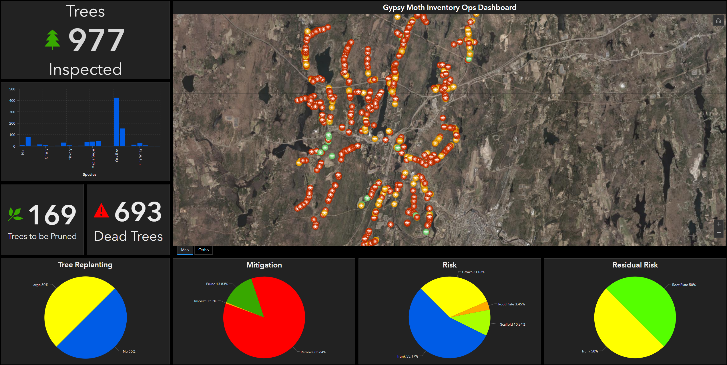
Our team put together a GIS app to map out tree inventory, allowing municipalities to pinpoint and treat the “hot spots” of Gypsy Moths that were affecting the trees.
Combining her skills in geography, cartography, and planning with the latest GIS tools, Kristen can paint a picture of how her team can address any problem facing a client and how GIS can improve communities.
“One of the nice things about a map is that it’s a picture at its most basic form and a picture is worth a thousand words. We use the demonstrations of our GIS experience to show municipalities and other clients what we have done for other communities and how we can design a solution specific to their needs,” explained Kristen.
As GIS continues to evolve, Kristen’s zeal for her career and helping her clients never fades.
“One of the things I love about it is how unique it is. The projects we do are so interesting, and we can apply this technology to any problem. So, coming up with the solution to people’s problems using this technology never gets dull.”