Capitalizing on Drone Usage for Safe, Cost-Effective Inspections and Assessments
By Adam Weber, Staff Engineer
Unmanned Aircraft Systems, or drones, as they are more commonly known, are becoming an increasingly popular and valuable tool within the engineering industry. From taking simple aerial photos to performing structure inspections or creating 3D models, the list of drone capabilities is extensive and continues to expand with advancements in technology. Capitalizing on the power of these drones has practical applications for engineers to manage projects in a way that creates a safe environment and is cost-effective for clients. Before sending your drone into the air there are some guidelines operators should follow.
Before Take-Off, Know Your FAA Regulations
Over just the past decade, the Federal Aviation Administration (FAA) has been issuing updated guidance and regulation to keep up with the growing demand for flying drones commercially, and it’s to be expected that these rules will continue to evolve as drones solidify their place as a powerful and helpful tool.
Prospective commercial drone operators should be aware that it’s not as simple as purchasing a unit and immediately putting it up in the sky. As the FAA has recognized drones as a type of aircraft, they must share the same national airspace with other aircraft such as passenger planes and helicopters, and are thus subject to strict rules to ensure the safety of all flights. Drones weighing more than 0.55 lbs. (which account for most of them) must be registered with the FAA, and all pilots wishing to operate drones for business purposes must be licensed to fly under Part 107. These are the set of rules governing commercial drone usage, which is achieved by passing a computer-based knowledge test.
After obtaining the necessary registration and licensure, it is imperative for the pilot to research the area surrounding the site to be flown. The United States airspace is one of the most complex in the world, and a significant portion of the Part 107 knowledge test is learning how to read airspace charts to determine where drone pilots can and cannot operate. For example, drones are limited to an altitude of 400 feet above ground level, however, the regions surrounding airports are considered controlled airspace for the purposes of safe takeoffs and landings and are often restricted from the ground level up within a certain radius of the runway. If a drone flight is to take place within controlled airspace, the pilot needs to request an authorization from the FAA and adhere to strict altitude limitations.
Although there is prep work to get cleared for a flight and ensure the site conditions and proposed flight route are compliant with Part 107 regulations, it is easy to understand why our sky needs to be kept conflict-free by holding drone operators to these standards. Plus, the deliverables produced by drones are sure to impress clients and the public alike, making the process well worth the time.
Maximizing Drone Features for Inspections and Assessments
Tighe & Bond currently operates two different drones: the DJI Phantom 4 Pro and the DJI Matrice 210. The Phantom is a very common and recognizable aircraft and is well-suited for general photography and videography, while the Matrice’s specialty is detailed inspections. The Matrice has the option of swapping out the camera as well as mounting it on top of the aircraft instead of using the standard underside attachment. These features can allow the pilot to install a variety of cameras such as a zoom lens or infrared camera, and by using the top mount location, gain the ability to point the camera above horizontal which is necessary for tasks like bridge inspections.
Modern drones are equipped with object sensors on most or all sides, stopping the aircraft in place if a collision is imminent. Coupling this onboard technology with a skilled operator opens the possibilities for close-range inspections where it makes more sense to use a drone instead of a person for accessibility and safety reasons. In fall 2019, Tighe & Bond performed visual inspections of a water tower and dam for Providence Water, flying the drone within feet of the structures and the water surface in order to record the highest resolution video possible for the client to review.
Often, a changing project site will not be reflected in satellite imagery online. Drones are an excellent way to obtain the most recent aerial photography of an area or even fulfill construction observation tasks without having to physically enter the site. Tighe & Bond uses a second flight control app produced by DJI, Ground Station Pro, which flies the drone on autopilot, capturing photos at regular intervals in a grid pattern over a specified coverage area. Using third-party post-processing software, these photos can be stitched together to create a high-quality, geometrically accurate aerial map. Additionally, some software can utilize the altitude data from the flight and triangulation between photos to turn the stitched aerial map into a 3D model with approximately 1-inch accuracy. Our team performed a 3D mapping flight at the Trap Falls Reservoir in Shelton, Connecticut to calculate the volume of residuals basins using one 5-minute automated flight instead of taking hours of hand measurements.
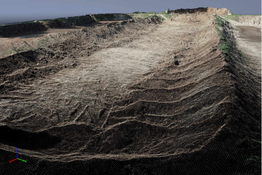
An example of a 3D model created from a mapping drone flight and third-party software.
Two of the most important drone features are its speed and flight range capabilities. Without them, the aircraft would be no better than a handheld camera. In clear, unobstructed conditions, most modern drones can be flown between one and four miles away from the pilot at speeds of around 30 miles per hour. Because of this functionality, large or inaccessible sites can be viewed and photographed with ease as the pilot remains stationary in a safe location. During summer 2019, Tighe & Bond staff helped oversee the application of alum to Lake Auburn in Maine, and a drone was used to monitor the operations and provide video documentation of the process to the client. Although the alum barge was over a mile from shore, our drone flew out to its location in just a few minutes and captured video directly above the point of application. Using the drone for this project had an additional benefit compared to just taking surface-level photos from a secondary boat. By pointing the camera straight down over the lake, sunlight reflection was eliminated from the picture, allowing the project team to clearly view how the chemicals were interacting with the water as time progressed.
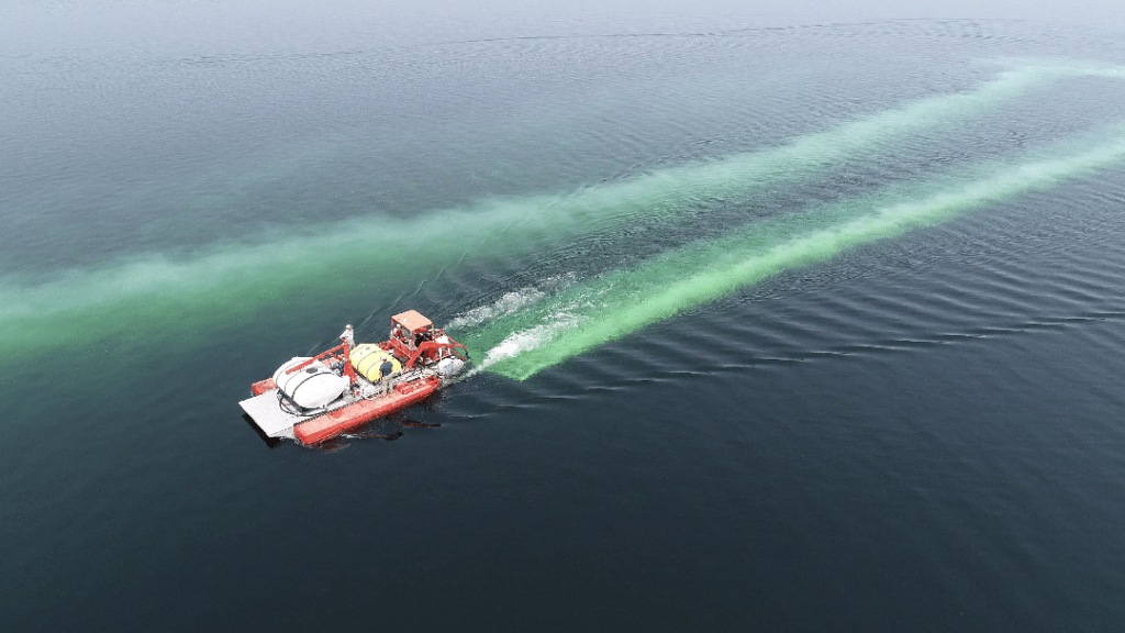
Tighe & Bond’s drone monitors the application of alum to Lake Auburn in Maine.
Drone Capabilities Allow for Work Across Many Engineering Fields
Drones have also proven to be assets in the transportation sector. While traffic observations have been largely taken by staff standing at an intersection or by cameras mounted to poles, the field of view is often constrained to a specific location and cannot show how a larger transportation network operates without employing many people or cameras. Drones, however, can ascend hundreds of feet above the roadway, and just one pilot can capture footage of multiple streets, intersections, and points of interest. The video can then be analyzed to determine the performance of a selected area or corridor holistically by examining queue lengths, wait times, origins and destinations, and travel speeds.
Clearly, there is no one fixed purpose for a drone, especially in the engineering field. As new projects bring new types of challenges, we must develop innovative and efficient solutions to ensure success. Drones have found their way into the equation and have proven to be an economical, safe, and reliable choice.
Check out some of the Tighe & Bond drone capabilities in the video below.